
Land Surveying and Land Development Software for Land Surveyors, Engineers, Architects and Construction
DTM
This software is designed to run on AutoCAD®, BricsCAD®, ZWCAD®, and IntelliCAD® based CAD systems.
IntelliCAD® based CAD systems include ActCAD®, Cadian®, CMS® and ProgeCAD®.
Digital Terrain Modeling (DTM) is also included in Land Development Suite and Survey and Cogo Suite.
Digital Terrain Modeling runs inside AutoCAD®, BricsCAD® or IntelliCAD® based CAD systems, giving you time saving contouring and profiling commands right inside your favorite CAD package!
Digital Terrain Modeling provides an economic solution for surface modeling and is suitable for use on Site Plans, Subdivisions and other areas where you need to show existing or proposed ground profiles, existing or proposed ground contours or where you need to get volumes between two surfaces.
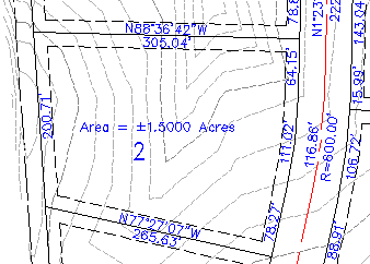
Any point file in the xyz format can be used to create a surface model. Objects may be selected from the screen. Fault lines may be added to the model to control the triangulation process. Boundaries and voids may also be used to control the appearance of the model.
Create a TIN (triangulated irregular network) of a set of points.
Set elevation limits on the surface model.
Contours may be created at user defined intervals.
Contours may be placed on user defined layers in the drawing.
A mesh may be created of the surface.
Volume calculations may be made between two surfaces.
Create an unlimited number of surfaces.
Import surfaces from a LandXML file or export surfaces to a LandXML file.
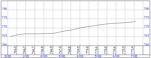
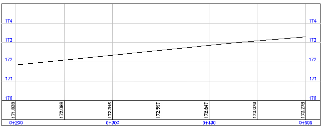
Select a polyline alignment and cut a profile from the surface. The profile may then be imported into a drawing. The program places a grid around the profile and annotates stations and existing ground elevations on a user defined interval. You may overlay the existing profile with a new profile cut from a modified surface model.
Select a polyline alignment to cut a section or profile along.
This can be as simple as a straight line or as complicated as a roadway alignment with horizontal curves.
Select 3D lines, polylines or 3D faces to cut a section or profile from.
Select existing contour lines or other topo features.
A section or profile is cut from these elements.
A fully annotated section or profile may be imported into your drawing.
The program places a grid around the profile and annotates stations and existing ground elevations on a user defined interval. You may overlay the existing profile with a new profile cut from modified topo features.
Digital Terrain Modeling (DTM) is also included in Land Development Suite and Survey and Cogo Suite.
Digital Terrain Modeling runs inside AutoCAD®, BricsCAD® or IntelliCAD® based CAD systems, giving you time saving contouring and profiling commands right inside your favorite CAD package!
Digital Terrain Modeling provides an economic solution for surface modeling and is suitable for use on Site Plans, Subdivisions and other areas where you need to show existing or proposed ground profiles, existing or proposed ground contours or where you need to get volumes between two surfaces.
Any point file in the xyz format can be used to create a surface model. Objects may be selected from the screen. Fault lines may be added to the model to control the triangulation process. Boundaries and voids may also be used to control the appearance of the model.
Create a TIN (triangulated irregular network) of a set of points.
Set elevation limits on the surface model.
Contours may be created at user defined intervals.
Contours may be placed on user defined layers in the drawing.
A mesh may be created of the surface.
Volume calculations may be made between two surfaces.
Create an unlimited number of surfaces.
Import surfaces from a LandXML file or export surfaces to a LandXML file.
DTM Profile Cutter
Select a polyline alignment and cut a profile from the surface. The profile may then be imported into a drawing. The program places a grid around the profile and annotates stations and existing ground elevations on a user defined interval. You may overlay the existing profile with a new profile cut from a modified surface model.
Also included:
Cut sections and profiles with NO surface model!
Select a polyline alignment to cut a section or profile along.
This can be as simple as a straight line or as complicated as a roadway alignment with horizontal curves.
Select 3D lines, polylines or 3D faces to cut a section or profile from.
Select existing contour lines or other topo features.
A section or profile is cut from these elements.
A fully annotated section or profile may be imported into your drawing.
The program places a grid around the profile and annotates stations and existing ground elevations on a user defined interval. You may overlay the existing profile with a new profile cut from modified topo features.
DTM
DTM Profile Cutter
English
Metric
DTM Manual
Go to Simple Road Design
Copyright © 2024 CogoSoftware. Powered by Zen Cart